-
 The ARC boat
 -
-
Water/wastewater
Major Flood Repair Helped by Remote Control Boat
Feb 05 2014
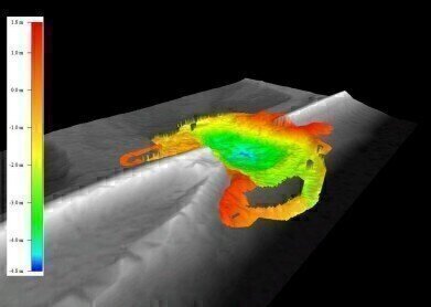
A remote control boat equipped with a SonTek M9 Acoustic Doppler Profiler (ADP) has been employed with HydroSurveyor software to create a 3-dimensional map of a damaged (and still submerged) flood barrier, following serious damage that took place during last December’s storms. Data from the survey enabled the Environment Agency to act swiftly and effectively to repair the damage and thereby protect local industry and residents.
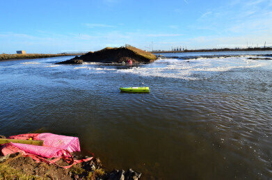
Extreme weather conditions and the highest tide for 150 years resulted in serious damage to a flood bank at Seal Sands near Billingham in the North East of England. A large hole, some 60 to 80 meters across, was scoured from the barrier and enormous quantities of seawater flooded into an area of marshland, which is an important wildlife habitat. However, this area is also adjacent to a number of high value industrial assets, so this breach in the flood defences represented a serious threat and urgent remedial action was necessary.
Initially, military helicopters were recruited to help drop boulders into the hole, but it soon became clear that greater volumes were required so a temporary road was quickly constructed along the barrier so that fill material could be delivered by lorries.
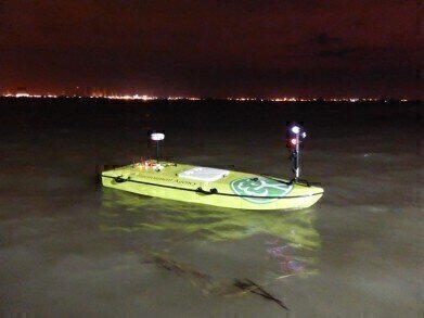
Unfortunately, the extent of the damage to the submerged flood bank was not visible, even at low tide, so it was necessary to be able to survey the damage in order to be able to calculate the type and volume of material that would be necessary for the repair operation. Traditionally, such surveys would have been conducted manually from boats using gauging poles, but the Environment Agency now employs advanced remote control boats that have a range of 200 metres, so operators are able to remain on the bank.
The M9 ADP on-board the remote controlled ‘ARC-Boat’ is a 5-beam depth sounding and velocity profiling device that scans the bed as the boat is guided across the water’s surface. Recorded data are analysed in real-time by the SonTek HydroSurveyor software to produce accurate depth and velocity measurements in addition to 3-D maps of the water body. The Agency’s Chris Train says, “The operation of the ARC-Boat was a great success; we were able to conduct a complete survey during about one hour of slack water at the top of the tide. As it happened, this was undertaken at night, but we attached navigation lights to the ARC boat, so the timing was of no consequence.
“The HydroSurveyor software created a superb map of the damage and demonstrated that the hole was significantly deeper than we had anticipated, so this data was essential in helping us to plan the remediation work.
“The main advantages of the ARC-Boat/HydroSurveyor system are the speed with which a survey is undertaken, the quality of the data, and improved safety because it is not necessary for staff to work on the water.”


Digital Edition
AET 28.4 Oct/Nov 2024
November 2024
Gas Detection - Go from lagging to leading: why investment in gas detection makes sense Air Monitoring - Swirl and vortex meters will aid green hydrogen production - Beyond the Stack: Emi...
View all digital editions


Events
Jan 12 2025 Abu Dhabi, UAE
Jan 14 2025 Abu Dhabi, UAE
Jan 20 2025 San Diego, CA, USA
Carrefour des Gestions Locales de L'eau
Jan 22 2025 Rennes, France
Safety, Health & Wellbeing LIVE
Jan 22 2025 Manchester, UK