Portable & field testing
Enhanced Lightning Detection System Looks into the Eye of the Storm
Jan 08 2014
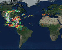
As we move away from 30th November and out of the official hurricane season, Vaisala (Finland) announces the public release of a unique lightning data set accompanying this year's record breaking Hurricane Patricia, as captured by the newly upgraded GLD360 global lightning detection network.
With a record breaking count of 30, the northern hemisphere has seen more major hurricanes and typhoons of category 3, 4 and 5 in 2015 than in any previous season. Particularly vigorous activity in the Pacific, attributed partly to a potent El Niño, has made a major contribution. While Sandra became the strongest hurricane to develop so late in the season, developing during the latter half of November, the year was underscored by Patricia in late October, which, with wind speeds of 200mph, became the strongest tropical cyclone ever recorded in the western hemisphere.
GLD360 provides continuous monitoring of storm events wherever they occur, and in comparison with the other tropical cyclones, the lightning associated with hurricane Patricia was particularly remarkable. It had sustained eye-wall lightning for more than 30 hours, a phenomenon not sustained for more than a few hours, in any tropical cyclone, since Super-Typhoon Haiyan, back in 2013, regarded as one of the strongest storms ever, with sustained winds of 195mph.
Says Ron Holle, meteorologist and lightning authority: "Patricia is now among the few storms that show lightning in a tight circle in the eyewall. More than 90% of named systems do not. Those that have continuous lightning along the track are typically very strong."
"For the last 5 years the GLD360 has provided excellent detection of cloud-to-ground lightning, and in the summer our team implemented a major change that dramatically improved the detection of cloud lightning flashes. Overnight the average number of global events the system detects per day increased from 3,000,000 to 6,000,000. The detection of total lightning has given us an even more detailed insight to lightning associated with storms like Patricia." says Ryan Said, lead Vaisala GLD scientist.
The recent upgrade improves the GLD360's performance, reinforcing its effectiveness for lightning and severe weather warning at both a local and regional level, and improves its value to meteorological agencies, providing additional lightning information within their own countries, and in neighboring countries and oceans.
It provides not only valuable information for organisations to keep their operations running efficiently, limiting costly down-time and keeping workers safe, but also an insightful view of global weather patterns and severe weather events.
Today the GLD360 is used by meteorological agencies, aviation, mining, shipping and governmental organisations across the globe including the US Federal Aviation Administration and the US National Weather Service.
Digital Edition
AET 28.4 Oct/Nov 2024
November 2024
Gas Detection - Go from lagging to leading: why investment in gas detection makes sense Air Monitoring - Swirl and vortex meters will aid green hydrogen production - Beyond the Stack: Emi...
View all digital editions
Events
Jan 12 2025 Abu Dhabi, UAE
Jan 14 2025 Abu Dhabi, UAE
Jan 20 2025 San Diego, CA, USA
Carrefour des Gestions Locales de L'eau
Jan 22 2025 Rennes, France
Safety, Health & Wellbeing LIVE
Jan 22 2025 Manchester, UK


