Air monitoring
The Orbiting Carbon Observatory Returns First CO2 Maps
Jan 05 2015
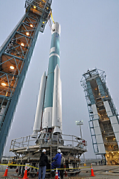
The Orbiting Carbon Observatory (OCO-2) has returned its first satellite images to Earth, pinpointing the location of carbon dioxide in our atmosphere. This stunning piece of equipment, launched into space in July by NASA, is designed to help determine exactly where the most amounts of CO2 are being emitted and absorbed across the globe.
The apparatus was only able to collect approximately five weeks of data during the months of October and November, but already from such data the team at NASA have been able to assemble the first satellite heat map showing the whereabouts of the harmful gas. This is a promising sign of things to come from the OCO-2.
Second Try’s a Charm
The OCO-2 is so named because it is Mark II in the OCO project. The first prototype suffered from a malfunctioning launch vehicle back in 2009, causing it to burn up upon re-entry into the Earth’s atmosphere without making a single measurement. The next five years were a painstaking struggle to tweak the equipment so that were no slip-ups second time around, and fortunately, everything went off this year without a hitch.
The device uses reflected sunlight and spectrometers to monitor carbon dioxide concentrations, thus allowing us to see not only its positioning but also its movement caused by wind and seasonal change. Therefore, in addition to gaining a bird’s eye view of how natural factors affect the placement of CO2, we can also see how we as a species affect it as well.
We can almost literally see our world breathe.
Better Monitoring to Lead to Better Control
These images are the first time we’ve been able to see the position of carbon dioxide concentrations with any certainty; up until we have relied mainly on educated guesswork and smaller-scale monitoring, as seen in Atmospheric Carbon Dioxide Monitoring. Though such estimates are valuable for identifying the problem of an over-abundance of CO2 in our atmosphere, they can’t pinpoint its location with the same precision that these latest maps are able to do. Furthermore, they are not able to provide us with the same data about how human activity is causing these CO2 build-ups.
For example, the hotspots of CO2 over South America and the southern regions of Africa most likely point to the combustion of biomass in these areas, while the industrialisation of China and the eastern coast of the United States are well-documented as sources of CO2 emission.
However, suspecting that these reasons are the cause and having the physical evidence at hand are two very different things. Hopefully, this new ability to screen the globe for CO2 emissions and absorptions will help to shape how we approach our attitude to this harmful gas in the future.
Now that we are able to watch our planet breathe, let’s make it breathe easier.


Digital Edition
AET 28.4 Oct/Nov 2024
November 2024
Gas Detection - Go from lagging to leading: why investment in gas detection makes sense Air Monitoring - Swirl and vortex meters will aid green hydrogen production - Beyond the Stack: Emi...
View all digital editions


Events
Jan 14 2025 Abu Dhabi, UAE
Jan 20 2025 San Diego, CA, USA
Carrefour des Gestions Locales de L'eau
Jan 22 2025 Rennes, France
Safety, Health & Wellbeing LIVE
Jan 22 2025 Manchester, UK
Jan 25 2025 San Diego, CA, USA